Axis Peak - 5.21.2014
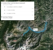
Directions to the Stuart Lake Trailhead from the junction of Hwy 2 and the Icicle Road.
|
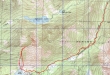
rodman's GPS track of this hike/climb in October 2009... basically the same route that we used on this trip... 11.2 miles roundtrip, gaining 4297 feet of elevation.
|
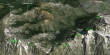
A google earth look at Axis Peak and the surrounding area.
|
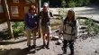
Gearing up at the Stuart Lake Trailhead (3540').
|
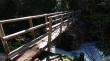
After hiking about 1.75 miles we made the only bridge crossing on this trip... Mountaineer Creek is running very fast.
|
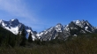
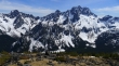
After hiking ~3.5 miles we reached a large meadow and got this look at Argonaut Peak (left), Sherpa Peak and Mt. Stuart.
|
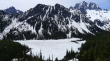
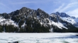
After hiking a total of 4.5 miles we have reached Stuart Lake... Mountaineer Ridge on the other side of the lake... with Mt. Stuart in the distance on the right.
|
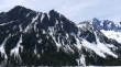
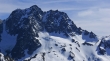
A closeup of Mountaineer Ridge (foreground) and Mt. Stuart.
|
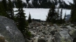
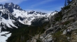
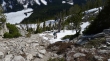
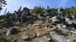
Leaving Stuart Lake and heading up the boulder field toward Axis Peak.
|
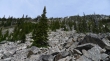
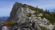
We can't see the Axis Peak summit yet. We will stay on the boulders until we can get beyond the brown patches of slide alder.
|
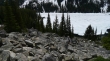
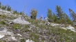
madman, Snowdog and BarbE ascending the boulder field above Stuart Lake.
|
madman on the boulder field above Stuart Lake... Mt. Stuart on the left.
|
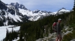
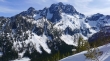
Gaining elevation quickly now... Mountaineer Ridge in the foreground... Argonaut Peak on the left... with Mt. Stuart on the right.
|
Snowdog on steep terrain.
|
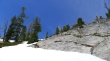
madman heading for the snow cover.
|
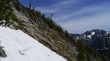
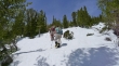
BarbE working her way over to the snow... Aasgard Pass on the right edge of the photo.
|
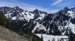
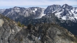
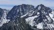
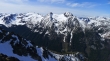
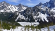
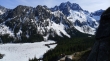
High enough above Stuart Lake now to see Sherpa Peak on the far right... Argonaut Peak in the center... with Dragontail Peak and Colchuck Peak on the left.
|
Off of the snow and back on dirt, gravel and boulders as we keep ascending.
|
Using crampons and spikes now.
|
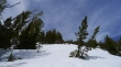
Continuing up on snow.
|
Not much snow on the ridge... BarbE, madman and Snowdog are heading for what looks like the summit... but I'm not so sure.
|
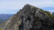
That looks like the summit to me... Icicle Ridge in the distance on the left... with Aasgard Pass in the distance on the far right.
|
Everyone is coming over to where I am after realizing that they were on a false summit.
|
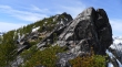
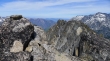
Awesome boulders on the summit ridge.
|
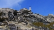
Someone has found the summit (7550') register... we were the first to sign in this year.
|
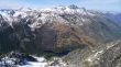
Colchuck Lake from the Axis Peak summit... with Aasgard Pass in the top-center of the photo... Cannon Mtn and Enchantment Peak are left of Aasgard... Dragontail and Colchuck Peak are right of Aasgard.
|
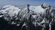
Argonaut Peak (left), Sherpa Peak and Mt. Stuart from Axis Peak.
|
Hi-Jack (left) and Eightmile Mtn (far right) from Axis.
|
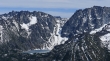
A closeup of Aasgard Pass (far left), Dragontail Peak (center) and Colchuck Peak.
|
A closer look at Colchuck Lake and Aasgard Pass above... Enchantment Peak on the left... Dragontail Peak on the right... we can see McClellan Peak beyond Aasgard Pass.
|
Enchantment Peak and a mostly melted-out Colchuck Lake... Aasgard Pass is starting to melt as well.
|
Group shot in front of Sherpa Peak and Mt. Stuart... Snowdog, BarbE, madman and ragman.
|

A selfie plus three on Axis Peak.
|
Looking down valley to Icicle Ridge... Cannon Mountain in the distance on the right.
|
Looking down on Eightmile Lake from Axis Peak... Cashmere Mountain on the right... with Glacier Peak in the distance on the left.
|
Eightmile Mountain (center)... with Hi-Jack on the left... Mt. Daniel in the distance on the left... Glacier Peak in the distance on the right.
|
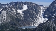
Avalanche on Mt. Stuart... we heard the explosion and it had already slid this much before I could get my camera out.
|
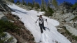
Snowdog descending... we stayed on the snow as much as possible on the way down.
|
BarbE descending toward Stuart Lake.
|
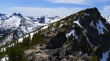
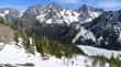
Descending toward Stuart Lake... Mountaineer Ridge in the foreground... Colchuck Peak and Argonaut Peak on the left... with Sherpa Peak on the right.
|
Mountaineer Ridge in the foreground... with Sherpa Peak and Mt. Stuart beyond... you can see the recent avalanche on Stuart... it almost reaches the valley floor.
|
Still descending... Aasgard Pass on the far left... with Dragontail Peak, Colchuck Peak and Argonaut Peak.
|
Off of the snow and on dirt and gravel for the last 800 feet of elevation loss back to the lake.
|
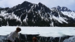
madman soaks up the awesome view... still a few hundred feet above Stuart Lake.
|
Finally back down to Stuart Lake... it is 5:30 pm and we still have a 4.5 mile hike back to our car.
|
