Mazama Ridge - 2.27.2012
|
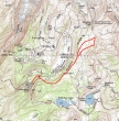
This map shows the approximate route of our trip to Mazama Ridge via Narada Falls... ~6 miles roundtrip... gaining ~1500 feet of elevation.
|
Drive 6.5 miles from the Nisqually entrance of MRNP to Longmire... then drive 8.1 miles from Longmire to the Narada Falls parking area (4564')... two cars today.
|
Walk a short distance past the rest rooms and maintenance shed... put on your snow shoes and hike into the woods... keeping an eye out for the orange and black stakes that will keep you on track.
|
With high avalanche warnings, we decided to not go up the steep grade to the Stevens Canyon Road.
|
It was 28 degrees and the foot of fresh snow was sparkling today.
|
|
We (mostly BarbE and Snowdog) carved out the trench today... following the orange and black stakes now.
|
Babes in the Woods.
|
Continuing along the treed route up to the Stevens Canyon Road.
|
On the Stevens Canyon Road... it won't be long until we cross the Paradise Valley Road and head for Mazama Ridge.
|
Mt. Rainier starting to come into view as we gain elevation.
|
|
Avoid the avalanche area above Narada Falls by taking this route to Mazama Ridge.
|
Still following the orange and black stakes.
|
Reflection Lakes or Mazama Ridge?... the route to Mazama Ridge isn't marked with the orange and black stakes from here... however, as long as you trend upward, you will be okay.
|
Heading up.
|
Looking south... The Castle and Pinnacle Peak are two peaks in the Tatoosh Range.
|
|
Unicorn Peak and Foss (aka Manatee) Peak come into view.
|
The Castle and Pinnacle are joined on the right by Plummer Peak and the flat-topped Denman Peak.
|
Denali Girl continues higher along Mazama Ridge.
|
A better view now of Unicorn Peak and Foss Peak.
|
Most of The Tatoosh Range... with Stevens Peak on the far left... and Lane Peak on the far right.
|
|
Castle, Pinnacle, Plummer, Denman and Lane.
|
Still gaining elevation.
|
Mt. Rainier comes into view as we go higher on the ridge.
|
Two more of the Tatoosh Range peaks come into view on the far right... Chutla Peak and Eagle Peak.
|
BarbE, Snowdog and Denali Girl break for lunch.
|
|
The view from our lunch spot.
|
Pyramid Peak from our lunch spot.
|
Stevens Peak, Unicorn Peak and Foss Peak.
|
A closer look at Unicorn Peak (left), the false summit of Unicorn and Foss Peak (right).
|
The Castle, Pinnacle Peak, Plummer Peak, Denman Peak and Lane Peak.
|
|
Denali Girl coming along Mazama Ridge... Unicorn and Foss behind.
|
Denali Girl and BarbE on Mazama Ridge.
|
BarbE and Snowdog heading for what will be our high point (5800+) for the day.
|
Snowdog and BarbE checking out the interesting trees.
|
Brrrrrr.....
|
|
At our high point... nice views in all directions.
|
BarbE and Snowdog admire the group shot setup.
|
A closeup of Unicorn (left), Unicorn false summit, Boundary Peak (thru the gap) and Foss.
|
Mt. Rainier and Little Tahoma from our high point.
|
A closeup of Little Tahoma.
|
|
A closeup of Mt. Rainier.
|
Walking out into the great wide open.
|
So many photo possibilities... so little time.
|
Heading back to the car now... Unicorn and Foss in the distance.
|
Storm brewing behind The Castle, Pinnacle and Plummber.
|
|
Pano shot of some of the Tatoosh Range... Stevens Peak on the left to Denman Peak on the right.
|
Denali Girl had started back before me... and caught me by surprise with this message.
|
Snowdog and BarbE wanted to shout out to everyone at nwhikers.net.
|
Can we beat the storm back to the car?
|
ragman and Snowdog heading for the barn... what a day!!
|


